Workbench (Navigation pane)
Workbench or Navigation pane is situated on the left-hand side of your Rapp Map browser window (Figure 2). The workbench consists of Location search (Search for locations), Data and analysis tools (Explore map data – Global, Australia, Regional Reports, Analysis Tools, My data / Upload), and the Legend for data layers which have been added to the map view.
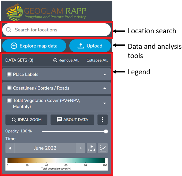
By default, three data set layers including Place Labels, Coastlines/ Boarders/ Roads and Total vegetation Cover are preloaded. When a data set is added to the map via the Data Catalogue, a legend for that data set will appear at the top of the Workbench.
From the Workbench you can:
- Show or hide the workbench
- Search for locations
- View the legend for displayed data and change how data appears in the map (See View details of each layer)
- Add and remove included layers and your own data
- Run time series analyses using fractional vegetation cover (see Analysis tools)
- Find regional fractional vegetation cover reports (see Reports)
- Set the order in which data is shown on the map (see Reordering the layers).
Show or hide the workbench
To hide or remove the workbench/Navigation pane, and enlarge the map view, click the X button at the top right side of the workbench/Navigation pane window.
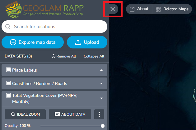
To show or restore the workbench (navigation pane) click ‘Show workbench’ in the top left of the map viewer.

Search for location
(YouTube video link: 3. Workbench - YouTube)
You may want to know more about the location where you are, find an address, locality, or map reference, find a region, or zoom to your own custom polygon or point using your own file.
To search for a location:
- Type a place name or address into the search for locations box at the top of the navigation pane on the left of your screen (RaPP map will begin searching as you type) You can also search for latitude and longitude. Enter in decimal degrees, e.g. - 31.9531, 141.47158 for Broken Hill.
- Select the best match from search results below the search bar. When you click on the search result the RaPP map view will zoom to your chosen location.
Click the x to remove search terms from the search box.
Show my current location
Use the current location button on the right-hand side of the map viewer. If you have location services enabled, this will zoom and centre the map at your current location.
Workbench legend
The workbench legend (Figure 16) displays details for each layer which has been added to the RaPP Map view. From the workbench legend you can:
- Expand and collapse the legend
- View details of each layer
- Hide, show, or remove data layers or data parts in the map view and time series charts
- Zoom to layer extent (ideal zoom)
- Set the display order of layers
- Set the opacity of some layers
- Choose the display date for time series layers
- Turn on and off the time series slider
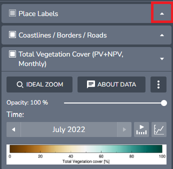
Expand and collapse the legend
To expand or collapse the legend for a data layer, click the arrow to the right-hand side of the layer name in the Workbench legend (Figure 16).
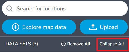
To collapse or minimise all legends for all data layers click Collapse all at the top of the workbench legend (Figure 17).
View details of each layer
When layers details are shown in an expanded format the legend may show:
- Ideal Zoom: zooms to layer extent
- About Data: view information about the layer in the Explore map data window
- Opacity slider: You can move the opacity slider to see the layer transparency change in the display. If you set the opacity to 0%, the layer will become completely transparent (Note: this is particularly useful when you want to see the underneath layer e.g. basemap of the location)
- Time box: for time series data the date of layer is shown, use the navigation buttons to view other dates from the time series
- The map legend explaining colours shown for this layer in the map viewer
Hide or show data layers or data parts
From the workbench legend you can choose to show or hide or remove layers in the map view. Showing and hiding layers is useful to quickly toggle between map views. To remove unwanted layers completely see Remove data and layers.
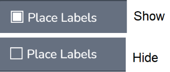
Hide, show, or remove data layers or data parts
- Solid white box = show
- Hollow box = hide