|
|
Chapter 1 |
|
Introduction |
|
Sections 1.1 to 1.5 |
1.1 |
Organization of the programs |
There are 30 or so programs in the TOPOG package, and these can be classified into four main categories:
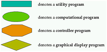
- Computational programs are those that perform geometric, analytical or numerical calculations.
- Utility programs are used to either translate , manipulate or interrogate output data files.
- Controller programs build files for input to other programs within TOPOG.
- Graphical display programs are used to display data which is input to and output from TOPOG.
The following symbols are used in the program flow charts provided in this chapter:
1.2 |
Glossary of program names |
Tables 1.1, 1.2, 1.3 and 1.4 provide listings and descriptions of the main TOPOG programs. These are classified according to their status as computational, utility, controller and graphical display programs.
Table 1.1 Glossary of computational programs. Note that programs Splin2h and Grdcon are integrated within program Topog_Demgen
Topog_splin2h Digital elevation model used to generate a grid of elevations at a user specified resolution Topog_grdcon Fits contours through elevation grid produced by Topog_splin2h Topog_element Segments a catchment contour map into an element network which is then used as the flow net for water balance computations; also computes a suite of terrain attributes for each element within the network. Topog_simul Predicts the spatial distribution of steady-state wetness, stream power, erosion hazard and landslide hazard indices. Topog_dynamic Simulates the dynamic water, carbon, solute and sediment balance of catchments. Topog_climate Climate simulator used to compute vapour pressure deficit and solar radiation on a horizontal surface; converts climatic data into a format suitable for input to Topog_dynamic. Topog_rcoeff Generates a table of coefficients, relating radiation values on a flat surface to those on inclined surfaces with discrete aspects. Topog_soil Soil hydraulic model used to generate psi/theta/conductivity relationships for use in the unsaturated zone module used in Topog_Dynamic
Table 1.2 Glossary of utility programs
Topog_overlay Coregister polygon maps onto an element network Topog_underlay Obtain the address of all elements lying within a polygon Topog_scanprf Convert a .prf file into a spatial map Topog_getatr Extract any column of data from a .atr file Topog_sumatr Summarises data stored in an .atr file Topog_param Calculate a suite of terrain properties from an .atr file Topog_mkweek Lumps daily data from a .bal or .car file into weekly totals Topog_mkmonth Lumps daily data from a .bal or .car file into monthly totals Topog_mkyear Lumps daily data from a .bal or .car file into yearly totals Topog_stripgen Generates an element network for an planar, concave or convex plan surface Topog_redflow Redirects flow paths in an element network Topog_xyzclip Clip points from a .xyz file Topog_cnsclip Clips parts of contous from a .cns or .tcn file Topog_rotate Rotate point, polygon or contour files Topog_reformat_tcn Reformats a .tcn file into flat file format Topog_trajectory Calculates trajectory lengths in an element network Topog_flowtube Calculates flowtube lengths in an element network Topog_ctb Produces a continuous greyscale colour table Topog_mkbdy Automatically generates .hpt, .sad, .vrt, .stl and .iws files.
Table 1.3 Glossary of controller programs.
Topog_demgen Controller program for programs Topog_splin2h and Topog_grdcon; displays . xyz, .grd, .cns and .tcn files Topog_simgen Builds and edits parameter files for Topog_dynamic
Table 1.4 Glossary of graphical displayprograms.
Topog _display Used to display spatial maps of model input and output files; also used to digitise polygons and search on data files Topog_chart Used to display time series data and generic column data arranged in free format Topog_profile Used to display vertical profiles of soil moisture (.prf files) as predicted by program Topog_dynamic Topog_xhistog Used to obtain a frequency distribution of any column file
1.3 |
Links between the programs |
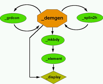
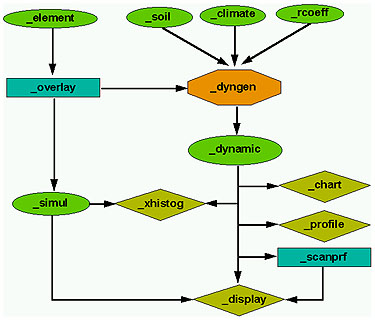
Figures 1.1 and 1.2 illustrate the linkages between the key Topog programs.Figure 1.1: Linkages between key TOPOG programs for Terrain Analysis.
Figure 1.2: Linkages between key TOPOG programs for Water Balance Modelling.
1.4 |
Filename structures |
TOPOG filenames consist of two, three, four, five or six parts, depending upon the type of file. The six possible attributes of a TOPOG filename are:
- a basename
- a qualifier
- a run number
- a day number
- a locator
- an extension
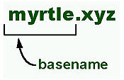
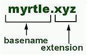
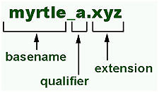
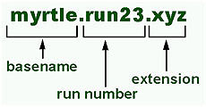
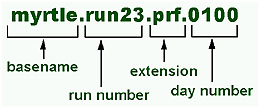
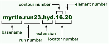
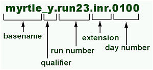
The basename identifies the catchment being analysed.
The extension denotes the type of file.
Qualifiers are used for all files which contain spatial data (ie: they can be mapped using Topog_Display). A qualifier is appended to the basename and consists of two parts; an underscore character and any lower case letter. The letter in the qualifier is usually used to record the version number of the file if several files are created with the same basename and extension. However, in other instances, the letter indicates the source of the file. For instance _y is used for all spatial data dumps from Topog_Dynamic.
Run numbers are used for all files output by the dynamic water balance model Topog_Dynamic. They indicate which simulation the particular output file arose from.
Day numbers are used for some files output by Topog_Dynamic. They are used wherever it is necessary to indicate that the data in the file pertains to a single day of a simulation. The day number is always appended to the extension.
or
Locators are used for some files output by the dynamic water balance models Topog_Dynamic. They are used wherever it is necessary to indicate that the data in the file pertains to a single element within the catchment. Locators are composed of two parts; an element number and a contour number. The locator number is always appended to the extension.
1.5 |
Filename extensions |
One of the confusing aspects of TOPOG is the large number of files which are created during a catchment analysis. Many of the TOPOG programs expect specific filename extensions. While the appropriate extensions are usually assigned automatically by different programs in the package, there are some instances where the user is expected to supply them.Appendix D lists all of the filename extensions which Topog imposes and/or assumes. While a few of the extensions shown are not mandatory, it is good practice to adopt these so that other users can decipher what you have been doing.
| Take me out of frames | on to Chapter 2 ....... |