



















| Name | Last modified | Size | Description |
|---|---|---|---|---|
| Parent Directory | - | ||
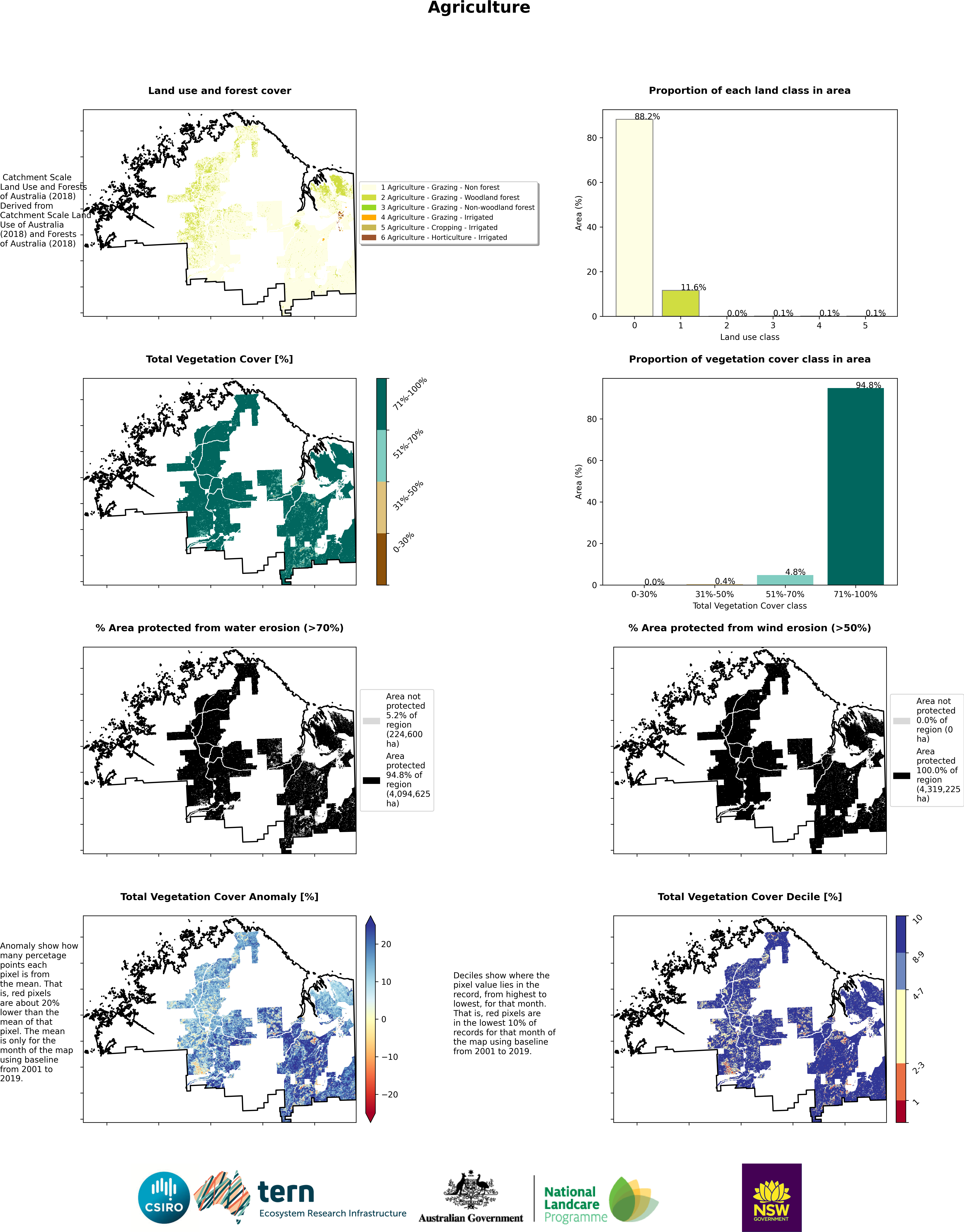
| agr_map.png | 2026-11-16 21:46 | 2.7M | |
| agr_timeseries.png | 2026-11-16 21:46 | 4.1M | |
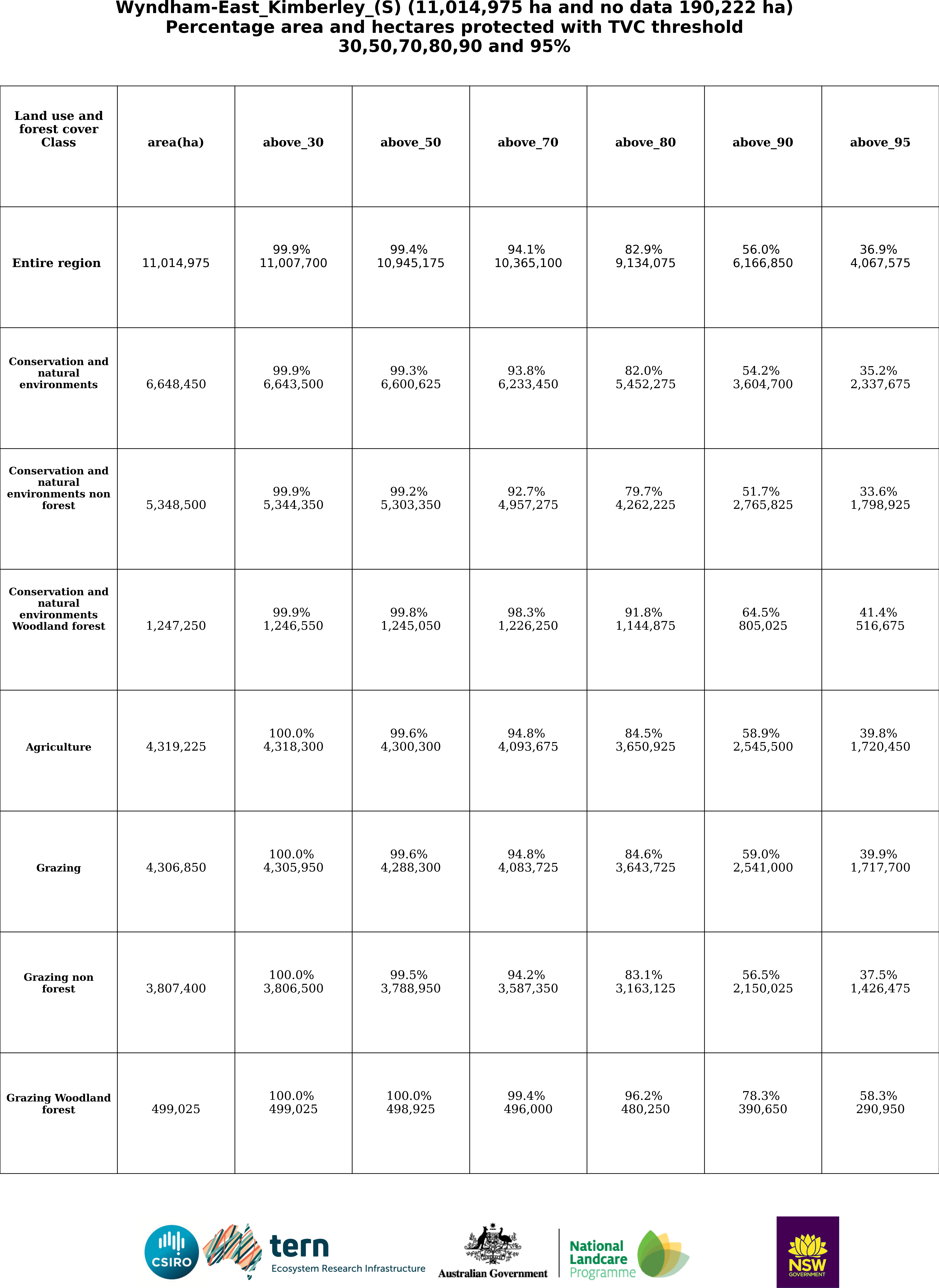
| area_table.png | 2026-11-16 21:49 | 1.1M | |
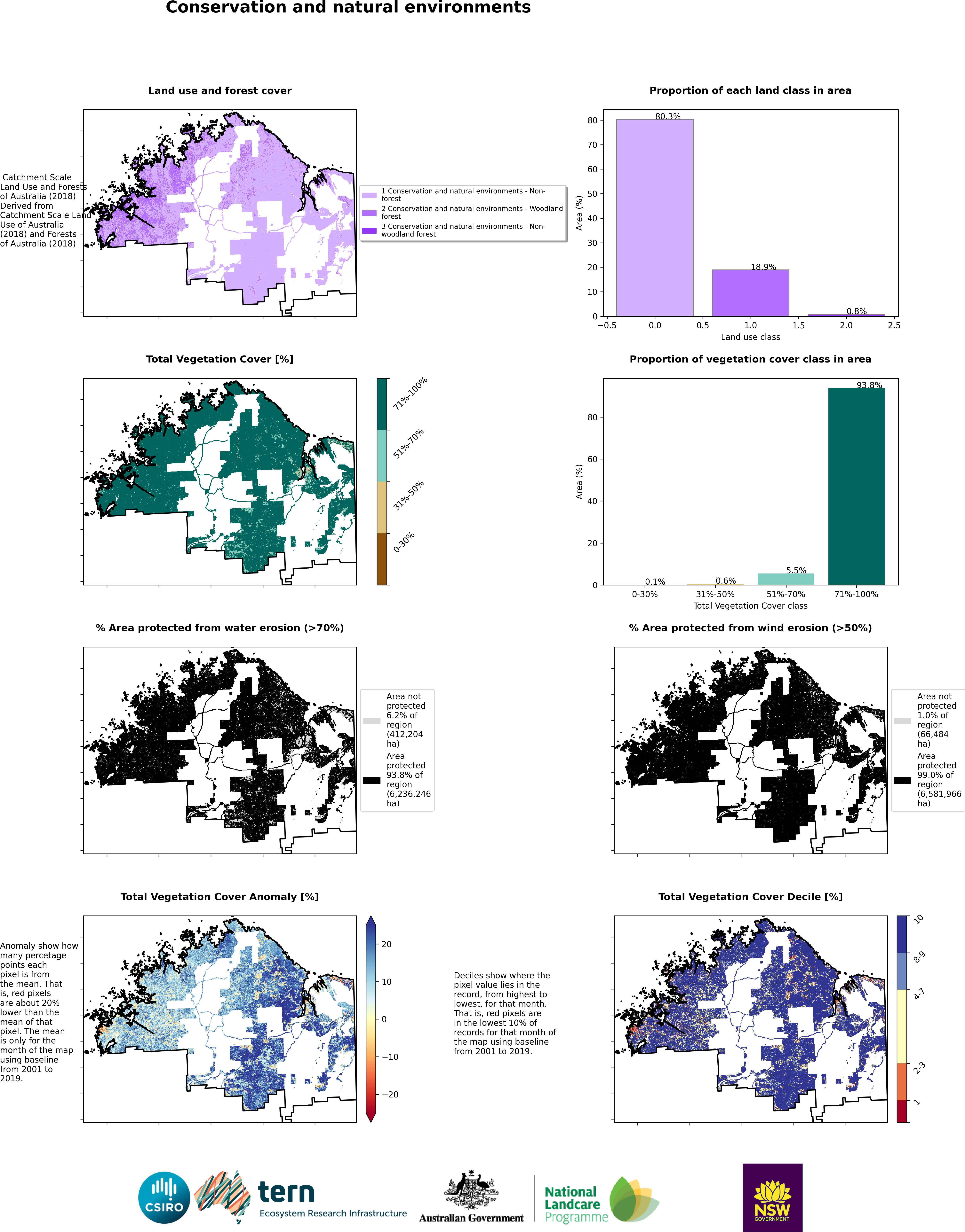
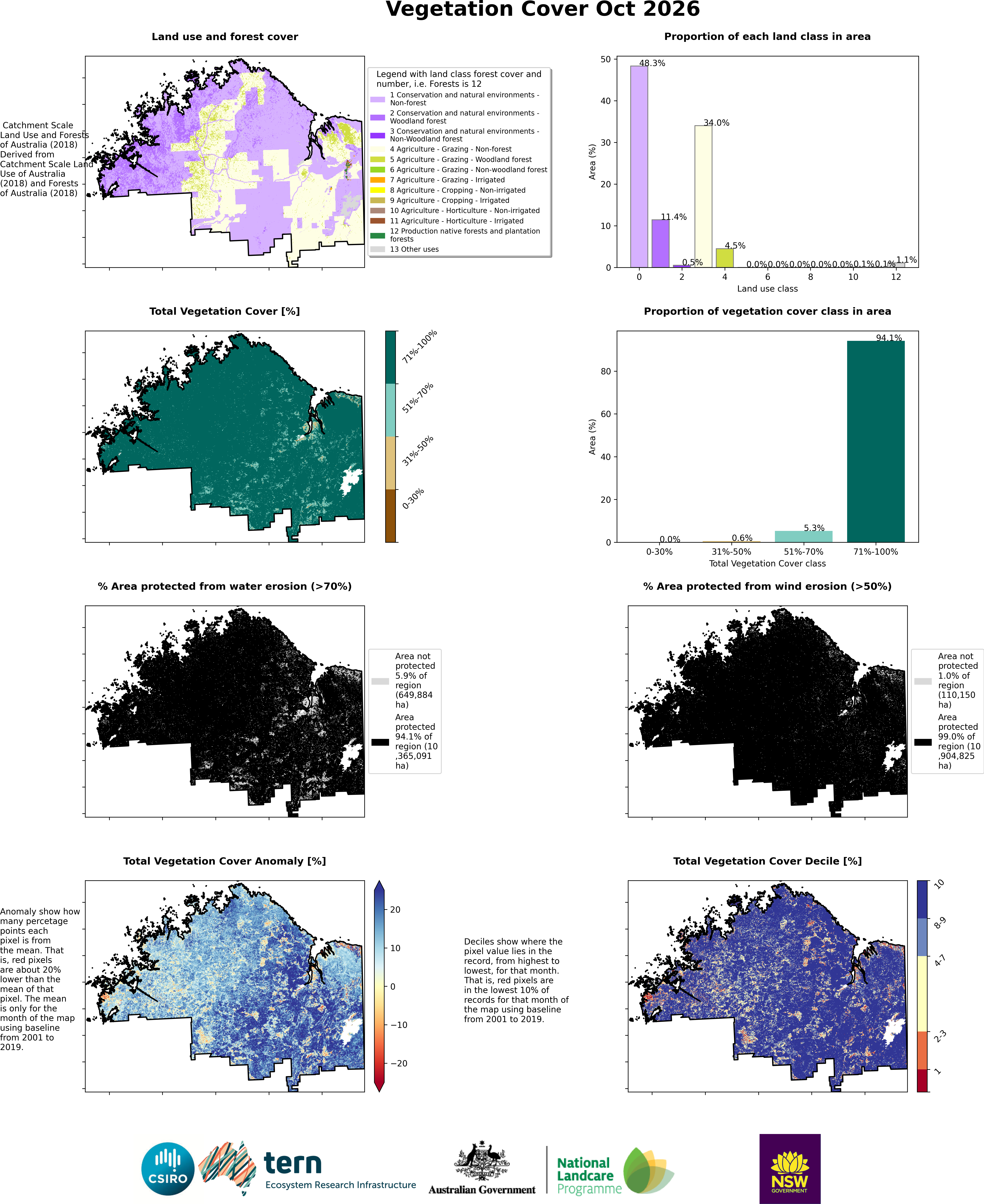
| cne_map.png | 2026-11-16 21:44 | 2.9M | |
| cne_nf_map.png | 2026-11-16 21:45 | 2.9M | |
| cne_nf_timeseries.png | 2026-11-16 21:45 | 4.2M | |
| cne_nwf_map.png | 2026-11-16 21:46 | 165K | |
| cne_nwf_timeseries.png | 2026-11-16 21:46 | 174K | |
| cne_nwf_timeseries_2.png | 2026-11-16 21:46 | 174K | |
| cne_timeseries.png | 2026-11-16 21:44 | 4.1M | |
| cne_wf_map.png | 2026-11-16 21:46 | 2.3M | |
| cne_wf_timeseries.png | 2026-11-16 21:46 | 3.3M | |
| crp_map.png | 2026-11-16 21:48 | 97K | |
| crp_timeseries.png | 2026-11-16 21:48 | 106K | |
| crp_timeseries_2.png | 2026-11-16 21:49 | 106K | |
| entire_region.png | 2026-11-16 21:43 | 3.6M | |
| entire_region_timeseries.png | 2026-11-16 21:44 | 4.6M | |
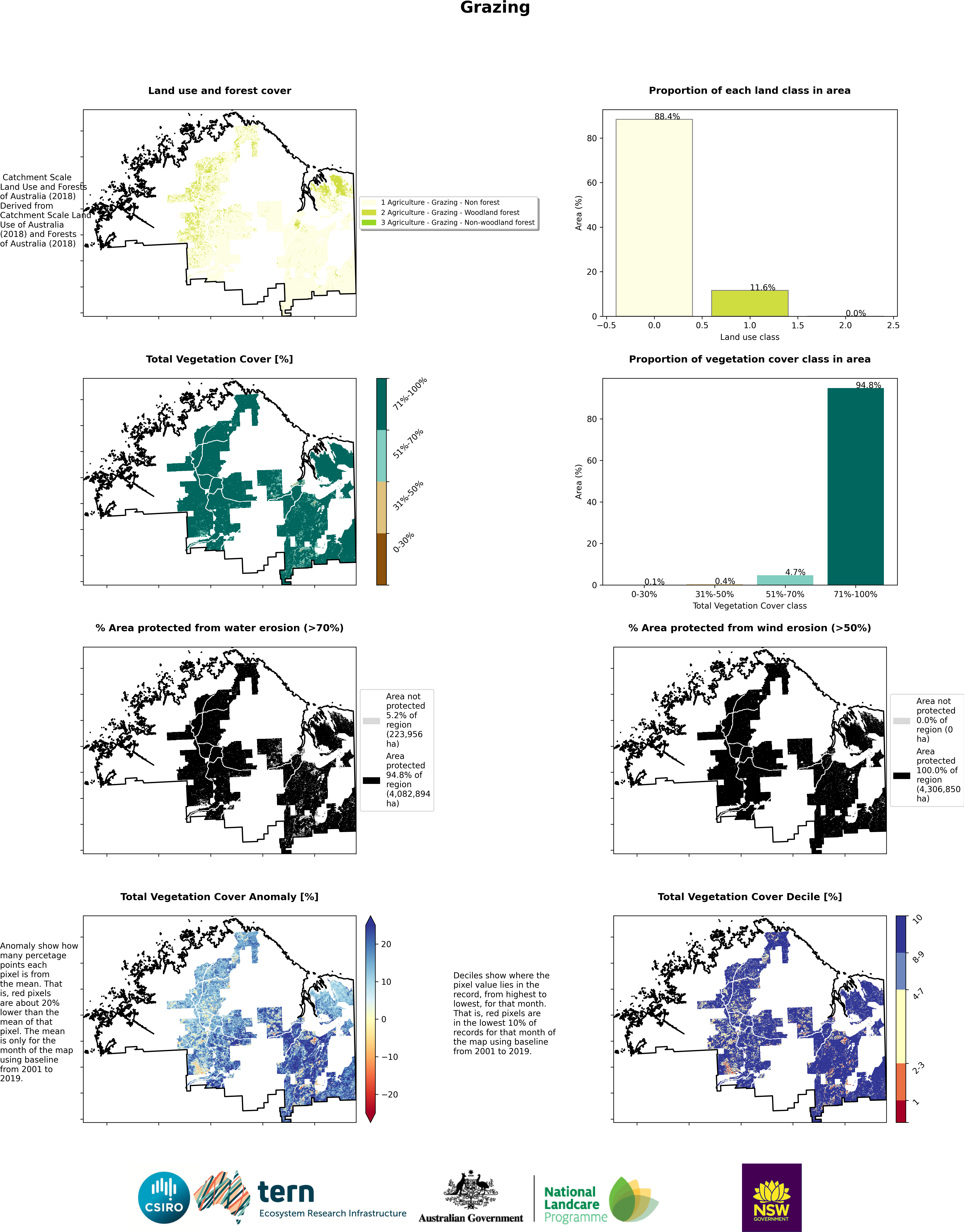
| grz_map.png | 2026-11-16 21:47 | 2.6M | |
| grz_nf_map.png | 2026-11-16 21:48 | 2.6M | |
| grz_nf_timeseries.png | 2026-11-16 21:48 | 4.1M | |
| grz_nwf_map.png | 2026-11-16 21:48 | 130K | |
| grz_nwf_timeseries.png | 2026-11-16 21:48 | 138K | |
| grz_nwf_timeseries_2.png | 2026-11-16 21:48 | 138K | |
| grz_timeseries.png | 2026-11-16 21:47 | 4.1M | |
| grz_wf_map.png | 2026-11-16 21:48 | 2.0M | |
| grz_wf_timeseries.png | 2026-11-16 21:48 | 3.2M | |
| hort_map.png | 2026-11-16 21:49 | 95K | |
| hort_timeseries.png | 2026-11-16 21:49 | 104K | |
| hort_timeseries_2.png | 2026-11-16 21:49 | 104K | |
| irr_map.png | 2026-11-16 21:49 | 94K | |
| irr_timeseries.png | 2026-11-16 21:49 | 103K | |
| irr_timeseries_2.png | 2026-11-16 21:49 | 103K | |
| pnf_map.png | 2026-11-16 21:49 | 146K | |
| pnf_timeseries.png | 2026-11-16 21:49 | 154K | |
| pnf_timeseries_2.png | 2026-11-16 21:49 | 154K | |
